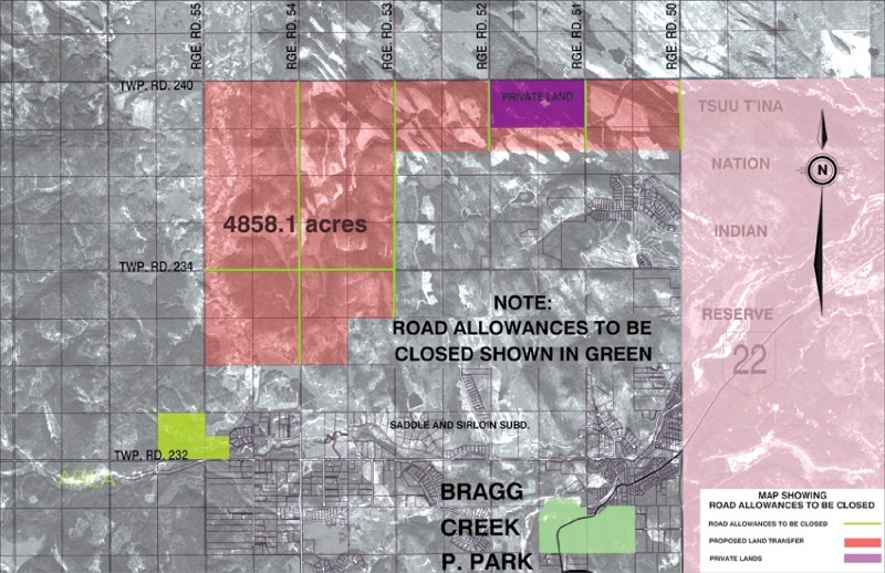
The Province has released a map of the crown land near Bragg Creek that may be part of a Calgary ring road land swap with the Tsuu T’ina First Nation.
The map reveals 4,500 acres of land north of Bragg Creek that were part of the 2009 failed deal between the Province and First Nation, which speculators think will form the basis for a new agreement.
It also clarifies which roads will be closed should the deal go through.
The map was released after Rocky View Councillor Rick Butler and Reeve Rolly Ashdown met with Minister of Transportation Luke Ouellette, Sept. 19, to clarify speculation about the swap.
“The map… makes it a little more clear,” said Butler. “At least we know exactly what we are dealing with.”
For some time, Butler has been fielding questions from concerned residents worried about the impact the deal would have on them. Of chief concern is access, with several landowners fearing their properties may be land locked.
Sections of range roads 50 to 54 and 234 will be closed, according to the map.
The crown land, currently being leased for grazing, was negotiated with no input from the community, according to Butler.
He said, “it would appear that this is the agreement that will be considered for finalization between the Tsuu T’ina First Nation and the Province.”
A number of rumours have been swirling about the timeline for such an agreement, with many opining that a deal would be made before Premier Ed Stelmach leaves office in October.
Butler said that deadline is now unlikely, adding that he doesn’t think there will be an opportunity for public input as the agreement is now in negotiation.
“We are maybe naively hopeful that we will have some input,” said Butler. “But that is doubtful at this late stage.”
Despite the concern, Butler said the residents wouldn’t want to stand in the way of the project.
For more information, visit www.transportation.alberta.ca


